Biriya Forest – Magic & Mysticism in the Upper Galilee
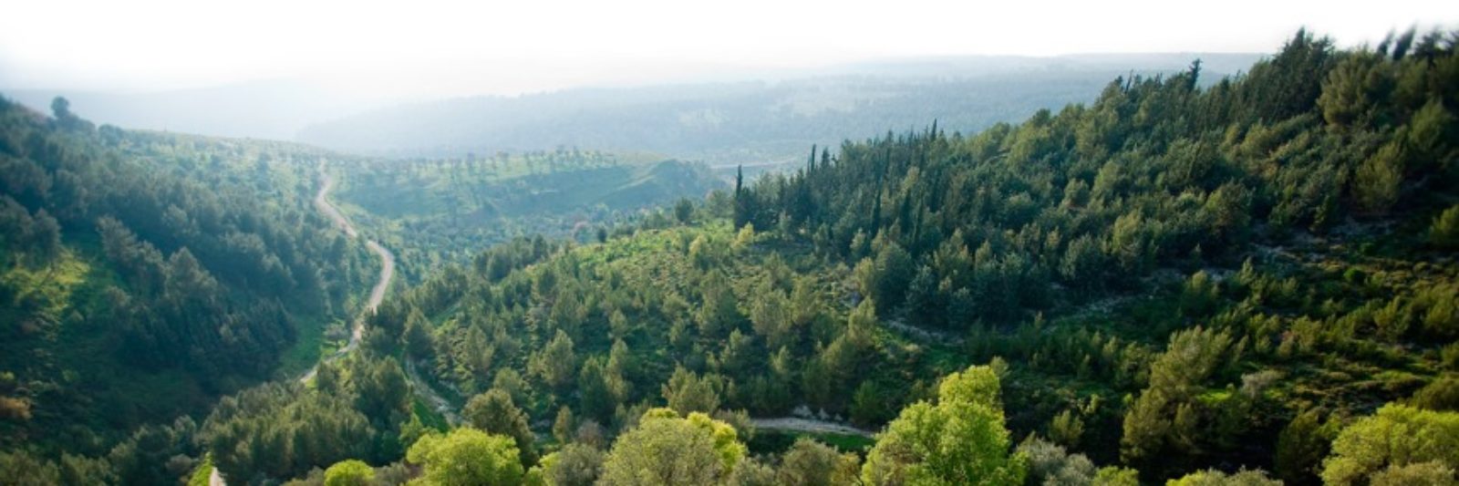
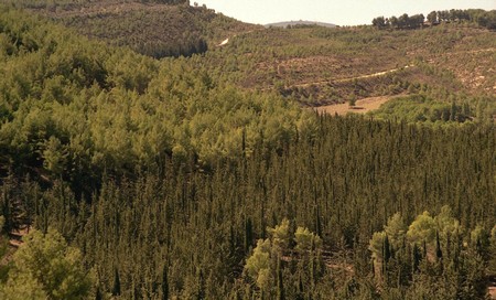
A sloping forest in the North of Israel: Biriya Forest is the largest planted forest in the Galilee, and is situated on the slopes descending east from Tzefat to Rosh Pina and Hatzor. Biriya boasts a variety of fascinating sites – groves, springs, an ancient synagogue, a lime pit, revered tombs, diverse flora, hiking trails and scenic lookouts.
About the Forest
Biriya Forest is the largest planted forest in the Galilee. It covers an area of 20 sq. km. on the slopes descending east from Tzefat to Rosh Pina and Hatzor, north to Dalton River, and west, to Amud River. It is no wonder that in such a big forest one will find a variety of interesting and fascinating sites – forests, groves, springs, an ancient synagogue, a lime pit, tombs of the righteous, diverse flora, and scenic routes and hiking trails with recreation areas and scenic lookouts.
In the middle of the forest is Biriya Fortress, a site that symbolizes the determination of the Jewish people to inhabit their land. Biriya Fortress is a visitors center at present, where visitors and students can learn, visually and interactively, about the history of Biriya, afforestation and local nature.
The heights of the forest reach an altitude of more than 900m above sea level. The air is fresh and relatively cool even in the summer, which makes Biriya Forest a good place to visit all year round. In the spring there are lush Galilee wildflowers—sage-leaf rockrose, which is known for its large white flowers, as well as anemones, buttercups, cyclamens, orchids and many others species of flowers.
In early summer, there is a profusion of yellow flowering Spanish broom, and all summer long, the spiny hawthorn bears round, sweet fruits that taste like apples. In the fall, you can see squills and crocuses.
Most of the forest is Jerusalem pine, although KKL-JNF varied the forest with other conifers, the Brutia pine and the Canary pine. There are other coniferous trees, too, such as the common cypress and the Arizona cypress, whose bark tends to peel. One of the more beautiful trees that can be found in a few of the forest groves is the Atlantic cedar.
KKL-JNF constructed many recreation areas in Biriya Forest, paved a scenic route that traverses the entire length of the forest, and blazed four marked trails that start out from the Biriya Fortress:
1. The Naburiya Trail (black) leads to the Tomb of Yonatan Ben Uziel;
2. The Fighters Trail (red) leads to Tzefat;
3. A trail (blue) that leads to Ein Yavnit; and
4. The Sternbergia Trail (orange) that starts at Mitzpe Amuka.
Each of these trails has a route map prepared by KKL-JNF, which can be obtained at the Biriya Fortress.
The Naburiya Synagogue
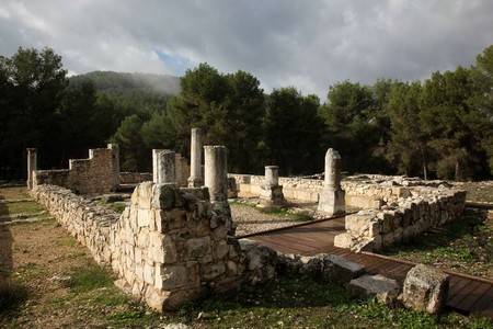 The village of Naburiya, which is located on the scenic road, existed during the first and second temple periods. Archeological excavations disclosed the remains of the synagogue, one of the oldest in the Galilee, which was constructed after the Bar Kochba revolt. The village was abandoned for 200 years following an earthquake, and in 564 the synagogue was rebuilt, as one may learn from the inscription on the lintel of its main entrance: “Built four hundred and ninety-four years after the destruction of the temple in the time of Hanina Ben Leizer and Luliana Bar Yudan.” This is a very important inscription. It dates the construction of the synagogue to 494 years after the destruction of the temple, when Hanina Ben Leizer and Luliana Bar Yudan ministered as community or synagogue leaders. An inscription on a synagogue with a date is very rare, and the inscription is on display at the Israel Museum in Jerusalem. The synagogue structure existed until around 640.
Under the shade of trees in the forest by the spring nearby, there is a beautiful recreation area. At the site of the synagogue there are two rows of four stone columns. The façade of the synagogue was partially reconstructed by KKL JNF and the Antiquities Authority, and thanks to a donation from friends of KKL-JNF from Canada, the paths around the synagogue were upgraded and the entrance was made wheelchair-accessible by adding an attractive wooden deck. Nearby, overlooking the synagogue, an assembly center was established, to accommodate visiting groups.
Biriya Fortress
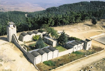 KKL-JNF, together with the Council for the Preservation of Sites and Buildings and the Biriya Fortress Restoration Organization, has turned Biriya Fortress into a fascinating site. In the time of the Talmud (700-300 BCE), there was an important town in the vicinity called Biriya, where famous sages lived. In the Middle Ages, Rabbi Yosef Karo lived in Biriya, where he completed the Orach Chayim section of the Shulchan Aruch in 1555. It seems the Jewish town was abandoned at the end of the sixteenth century. Biriya still had an important role to play, however. In 1908, Baron Rothschild purchased the lands of Biriya for the farmers of Rosh Pina, and a group of workers attempted to settle there in 1922 but were unsuccessful. The lands of Biriya were transferred to KKL-JNF, which began planting the forest.
Years passed. In the aftermath of World War II, on January 8, 1946, the Religious Brigade of the Palmach founded a community at this site, and they worked with KKL-JNF on land development and tree planting. Because iron was scarce, the fortress in Biriya was built with double walls made of stone. Consequently, the roofing was constructed on vaults, a style unique to the Biriya Fortress. The vaults were made with drainpipes and channels that conducted rainwater to a reservoir, which supplied all the water needed by the new settlement.
In a room on the southern path, you can see a replica of the water collection in the well. The fortress had two watchtowers and a lookout. These towers served, among other things, as a means of communication between the Jewish community of Tzefat and the Upper Galilee headquarters of the Hagana in Ayelet Hashachar. The people of Biriya assisted in smuggling Jews from Syria to the land of Israel.
In February, 1946, the British discovered two caches of weapons outside the encampment, where a Palmach unit had hidden arms after an unsuccessful assault. The British detained the 24 members of Biriya, incarcerated them in Akko and took over the stronghold. The Jews in the land of Israel refused to accept the harsh decree and, after about two weeks, around midnight on the rainy night of 11 Adar, the Hagana organized Operation Gidem. On the pretext of visiting Tel Hai, 3,000 people equipped with supplies established Biriya 2, a new Jewish settlement near the fortress. All movements were represented – Hapoel Hamizrachi, Hashomer Hatzair, Beitar, Hagana, country folk and city folk, religious and secular.
The British were stunned and waited for the thousands to disperse, but it didn’t happen. When they ran out of patience, they attacked the new stronghold, demolished the buildings and evacuated by force the 150 people who still remained. When this became known, hundreds of people from the area went to Biriya and started building Biriya 3. In view of their resolve, the British army retreated and allowed the pioneers to stay there. After about three weeks they were replaced by Bnei Akiva Seed Group 5, and two months later the British abandoned the fortress, so the group went to live there, and they were later replaced by Bnei Akiva Seed Group 6.
Biriya symbolizes the struggle of the people of Israel for their land. The mountain on which the fortress stands is called the Mountain of the Bold in honor of the pioneers. The fortress has become a wonderful museum that documents the site’s history. On one wall of the fortress, across from the canopy, there is an exhibition of pictures and documents. In the dining hall you can see a 12-minute film about the site. Groups of visitors may compile a computerized newspaper for themselves with media news about Biriya from the past.
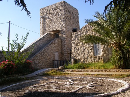
The Lookout Tower at Biriya Fortress
The Biriya Fortress lookout tower has become one of the fortress’s main attractions. In the past, almost all visitors to the site wanted to climb the tower to enjoy the surrounding view, but were not allowed to do so for safety reasons. For years the tower stood closed and abandoned, until donations from friends of KKL-JNF from Canada enabled it to be opened to the public. The upgrading of fortress tower was made possible through the generous support of Frank A. & Judith Wilson and family from Toronto, Canada and the participants of the 6th annual golf tournament of JNF Toronto, Canada. A flight of stairs was added, so that visitors could climb up, and a decorative glass floor was constructed at the top of the tower, allowing light to penetrate the entire building.
In the past the tower served as a means of maintaining contact with other communities in the area. Recently a combat veteran presented the site’s management team with the signal lamp that members of the Palmach had used to send messages from the tower in Morse code. This lamp will be on display at a special exhibition at the site’s museum.
The Scenic Road
The Biriya Forest Scenic Road is about 12km long and connects many of the sites in the forest. It is a high quality dirt road (some segments are paved) suitable for all motor vehicles. Marked with green arrows, the road begins at the Rosh Pina – Kiryat Shemona highway (90) slightly north of the Mahanayim Junction and ends south of Moshav Dalton (Highway 886).
A few hundred meters from the busy junction, the Mahanayim Recreation Area provides a haven from the traffic on the highway. Here you can prepare before spending more time in the forest. There is another recreation area in Ein Makled, further on up the road. The small spring flows into a manmade pool (it is dry in the summer). There is a burial cave near the spring. The road continues to climb in the forest and reaches a junction. Turn right to go to the Tomb of Yonatan Ben Uziel.
Turn left to continue on the scenic road, which is paved here. Proceed about 1km and turn right (west) before Amuka. From here on, the scenic road becomes a dirt road. The first turn on the road reveals Ein Yavnit, a spring that flows all year round. Near it are orchard trees and white poplars.
Next stop is Ein Naburiya. This is the spring of the ancient village of Naburiya. The spring flows all year round from a small cave in a large shiny area of white chalk stone, in which troughs were carved for watering herds and washing laundry. There are amphibians in the pool all year round, such as salamanders, newts, frogs and toads, and KKL JNF built terraces, planted fruit trees and turned the place into an enchanted garden.
Proceeding from Ein Naburiya on the scenic road, you will arrive at the Ancient Synagogue of Naburiya, which was previously described, and on the side of the road ascending southward, about 200m from the junction, is an ancient lime furnace. Lime furnaces were very important in ancient times. They made lime by burning chalk from the vicinity and used it to line walls of houses and cisterns. The walls of this lime furnace have been restored to a height of 4m.
Further west, toward Ein Gevar, one passes the Pistachio Valley. Pistachio trees were planted here in 1963. The yield, in September, is available for visitors. Ein Gevar is a spring that flows all year round. The British erected a building over it with a small pool next to it, an orchard and an herb garden. Under the shade of the trees in the forest, east of the spring, there is a recreation area for visitors, which was constructed by KKL JNF and is wheelchair accessible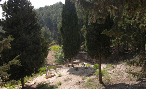
Near the exit from the scenic road to the Ein Zeitim Highway (886), KKL-JNF constructed two other recreation areas, the Dalton River Recreation Area and the Dalton Road Lookout. Both recreation areas have great views of Dalton River and the Hula Valley. The scenic road ends about 500m further, not far from the Ein Zeitim Recreation Area, which is on the side of the road to Dalton (886).
The Ein Zeitim Recreation Area is an active leisure recreation area, with picnic tables and wheelchair accessible parking. There was a village here named Ein Zeitun, which was inhabited by Jews from the Middle Ages until the early eighteenth century. Since then, four resettlement attempts were made, but they all failed. The recreation area has bio lavatories, a potable water fountain, grilling facilities, an obstacle course 120m long, and playground equipment for children. Near the recreation area there is a monument commemorating armored corps soldiers who fell in the battles on the Golan Heights during the Six Day War.
Tombs of the Sages
Another important site is the tomb of Yonatan Ben Uziel, the great disciple of Hillel the Elder. In one of his commentaries, Rabbi Yonatan noted that one must not delay the meeting of a bride and groom, so there is a custom for hopeful singles to visit his grave. The place has become a popular pilgrimage destination and has a stand with souvenirs and Judaica for sale. KKL JNF constructed a recreation area adjacent to the parking area with running water and bathroom facilities.
Near the synagogue ruins are the tombs of Yaakov Ish Naburiya, who lived in the fourth century, and Elazar Hamoda’i, who was from Modiin and was one of the sages of Yavne. According to a legend, he was an uncle of Bar Kochba and, according to the same legend, Bar Kochba put him to death during the siege of Beitar, because he was afraid his uncle would appease the Romans.
West of Hatzor Haglilit is the tomb of the renowned sage Honi Hame’agel, a popular favorite. Many people make the pilgrimage. Honi is famous for making rain come down in a time of drought. In the Mishnah it says, “He drew a circle, stood inside it and said, ‘Master of the world, I will not move from here until you have mercy on your children,’ and it began to drizzle. He said, ‘I did not ask for this but for gracious rains of blessing and beneficence,’ and then the rain came down properly.”
All the above information is curtesy to Keren Kayemeth Le’Israel Jewish National Fund